
Only memories remain
|
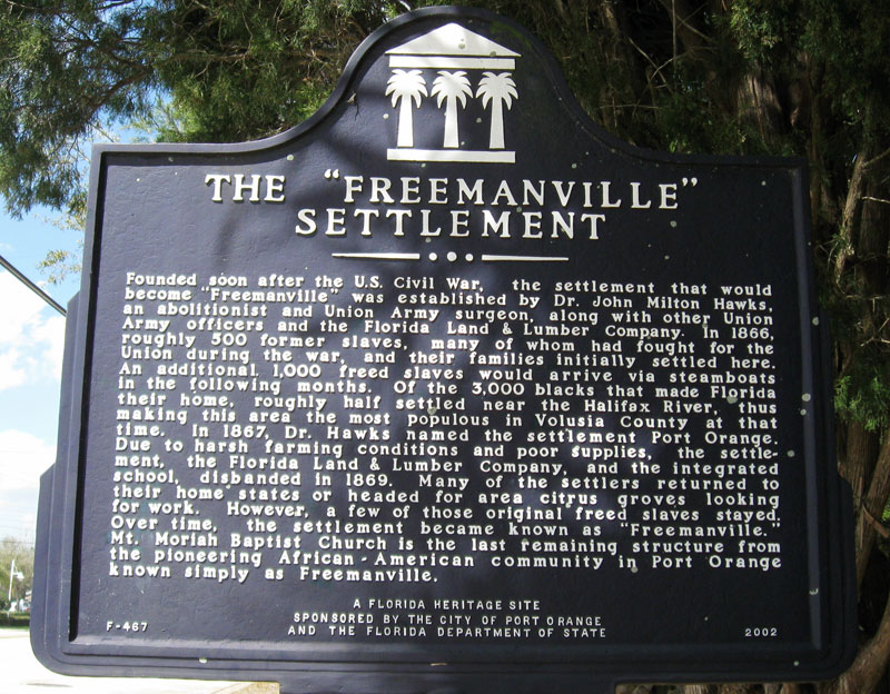
State landmark denotes the location of the abandoned community of Freemanville, settled by 500 freed slaves near the Halifax River in Port Orange in 1866. Click to zoom and read.
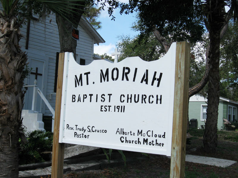
Below, Mt Moriah Baptist Church, the last remaining structure in Freemanville.
|
|
When I was ten years old we would visit my grandmother in Morley, Missouri (pop. 400; and just outside her back door by the large vegetable garden was an old well pump that always had a metal bucket and dipper. No water ever tasted colder, and no water was ever sweeter. She warned us, though, never leave the bucket empty because if the pump needs priming, you have to have water to pour into the pump or you’ll never get any more water.
I guess that’s what this blog is doing–priming the pump again. Church Mother Alberta McCloud had to convince her family to move to Freemanville because “This was out in the woods.” 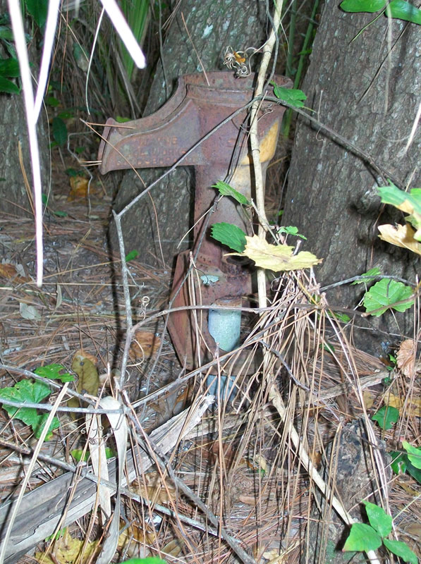
Last February after the Freemanville Day Celebration, I moseyed into the woods on the south side of Mt. Moriah Baptist Church, hoping to spot the rusty water hand pump of the bygone heydays of the community. Other than the pump, the church, and memories of nostalgic residents of 50 years ago, little else remains of what local historian Harold Cardwell referred to as a “ghost settlement.”
I had just heard “Mother Alberta McCloud” reminisce about what Freemanville was like when she and her husband, Rev. Nathaniel McCloud, first made a home together there more than 60 years ago. She said that she had to convince her family to move there because, as she said, “This was out in the woods.” Known as “Mother McCloud,” the church mother, she recalled raising 11 children, along with pigs, geese, and guineas in this quiet community. One day her husband brought home a goat, and another day he brought in a gopher tortoise and said that they could eat it, but she quickly corrected him – that HE could eat it. Life with these dirt roads, outhouses or sceptic tanks, and hand pumps for well water is remembered lovingly by those who experienced the times when the Freemans of Freemanville “would cook fish sandwiches and sell them to neighbors” in a picnic atmosphere on weekends. The African-American residents of the unincorporated community of the 1950s “worked in boatbuilding, netmaking, and hotel work,” as Port Orange Mayor Allen Green recalled last June in a panel of four “old-timer” Port Orangers, and he remembered that Freemanville had 10 to 15 families back then. He summarized those times when interviewed for Mary Corliss and Dorothy Dobbins’s book about Freemanville, A Free Man’s Dream (2003). “If you came from our community, the majority of the people ate out of the river,” he was quoted as saying. Virginia Moser, daughter of Alberta McCloud, told Corliss and Dobbins that she recalls that in those days she and the other children picked wild blackberries and mulberries for a Sunday treat – cobbler-like desserts they called “doobies”; and as recently as 2003, those wild berries were still growing in yards on North Orange Avenue and Valley Street. Traces of Freemanville aren’t easy to locate. Maxine Cullen who now lives in New Smyrna Beach grew up in Freemanville, as did her father Leroy Smith with her grandparents, and she recalled to Corliss and Dobbins, “It wasn’t really called ‘Freemanville’ like it is now; everybody just knew it was that area of Port Orange.” Early Freemanville citizens included Thaddeus Gooden and John Tolliver, son of Henry Tolliver, and as Daytona State College historian Len Lempel‘s research has documented, these two African-Americans were among 26 electors who voted to incorporate Daytona in 1876. Gooden worked at Palmetto Colony House in Daytona, and Tolliver engineered important sections of Ridgewood Avenue (later to become U.S. 1). Within five years, by 1881, Daytona had a population of 350, and during the 1880s, as Lempel has said, Daytona had integrated neighborhood homes with African-Americans comprising 25 percent of Daytona. |
Photos courtesy of Greg Milliken, Vintage Daytona. vintagedaytona.wordpress.com
The freezes of 1894-95 destroyed many orange groves, so men of Freemanville went to Daytona for work. The majority of Blacks moved from the Mr. Zion Methodist Church in Freemanville to New Town, a Black community in Daytona. World War II also took residents from Freemanville at the time that all of Port Orange had a population of only 600. Bad storms of 1947, 1949, and 1956 may also have made living in Freemanville more difficult. One such storm flooded the river to U.S. 1. Alexander Avenue memorializes one of the Black Civil War veterans, but no tombstones remain today because wooden markers have been lost over the years. Local historians Priscilla and Harold Cardwell wrote that Freemanville before the 1930s extended east across Dixie Highway, which became U.S. 1 in 1931. Its roads included West Ocean Avenue (south), Valley Street (north), Alexander Street (west), and North Orange Street (east) with Magnolia Street also lying within this section, running parallel with West Ocean Avenue.
The Cardwells also documented with old maps that Settlement Road ran north and south through Freemanville. A map handwritten from memory by Maxine Cullen indicates that “section quarters” homes, including hers, were along a dirt road north of Valley Street. This appears in the book by Corliss and Dobbins. The Cardwells have noted that what was known as the old Spanish Canal (or Daughtry Canal) drains the hammock and runs east from Freemanville just north of Magnolia Avenue from Alexander Street, crossing North Orange Avenue, and U.S. 1 into the Halifax River just to the north side of the Port Orange-South Daytona Chamber of Commerce. 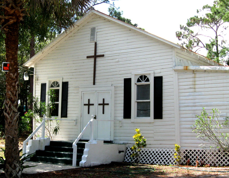
The main canal and smaller ditches were originally dug before the Second Seminole War of the 1830s so sugar cane could be grown on the Dunlawton Plantation.
If you want to see a birds-eye view of the canals, they’re still visible using Google maps (maps.google.com), then typing in “West Ocean Avenue Port Orange FL,” then clicking to zoom in to see the Spanish Canal running east-west just north of West Ocean Avenue with the Daughtry Canal branching from the south, flowing north to join the Spanish Canal. Another small canal also runs from the north, crossing Valley Street and running behind a large building on the west side as this small northern branch drains south to the Spanish Canal. (Daughtry is the correct spelling.) Valley Street, once a main road of Freemanville, was still unpaved as late as about the year 2000. Settlement Road led to Gadsden Cemetery where, according to the Cardwells, three Black union soldiers were buried: Watson, Tolliver, and Alexander. Alexander Avenue memorializes one of those Black Civil War veterans, but no tombstones remain today because wooden markers have been lost over the years. As the Cardwells have noted, poor residents, instead, would dig up wild coontie plants or cedar trees and transplant them to mark a gravesite, knowing that they would withstand drought and freezing winters. Alberta McCloud told Corliss and Dobbins, “You can tell where the graves are because of the cedar trees. We found one tree with [cinder] blocks around it.” Gladys Smith, wife of Leroy, told Corliss and Dobbins that she had moved to Freemanville when she was 17 and that she avoided the cemetery because of rattlesnakes. In 2003 she said that the graves’ locations are lost, saying, “You couldn’t find them if you had to.” |
Previous posts
Daytona Beach ends Stan Musial's pitching career
and aims him to the Hall of Fame
How Daytona Beach teens' lives changed during World War II
Daytona Beach ends Stan Musial's pitching career
and aims him to the Hall of Fame
How Daytona Beach teens' lives changed during World War II
Denny Bowden, Ph.D., writes about Volusia County history on the blog,
Volusia History - Retracing Florida's Past.
His work is reposted here by permission.
Read more of his Denny's blogs at http://volusiahistory.wordpress.com/
Volusia History - Retracing Florida's Past.
His work is reposted here by permission.
Read more of his Denny's blogs at http://volusiahistory.wordpress.com/